TRAVEL INDIA TRAVEL

India's boasts of one of the world's fastest growing economies and though India has averaged an annual growth rate of 9% in recent years there is still a vast majority of the country that lives below the poverty line and have little benefit from the economic boom. One of the largest challenges faced by the Indian government is to spread the bounty of the economic success across all margins of society. This comes across as a challenging task as it has been estimated that the poverty in India is set to rise if its population growth is not stopped in time.


History and Culture of India


Delhi, India's capital city has not always been its capital but has been an important gateway city and has immense historical and cultural significance. The city is the political seat of India and is famous for its many historical monuments like the Red Fort, Jama Masjid, the India Gate and Qutub Minar to name a few.


Indian Religion


India is also known for being a secular nation and has people from faiths ranging from Hinduism, Islam, Sikhism, Christianity, Buddhist, Jains and Parsis. Indian Religion is a way of life in India to the extent that rivers are held sacred, cows are worshipped and worldly sins washed away by a dip in the River Ganga. 


Tourist Destinations in india


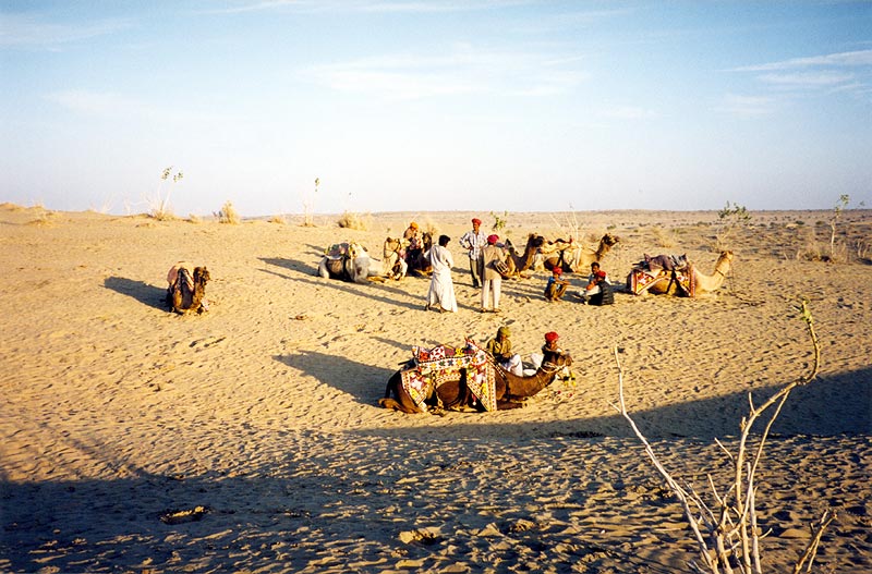
Owing to its extreme diversity, India makes an interesting tourist   destination as it can offer tourists snow capped mountains, sun kissed beaches, intricately designed temples, forests bursting with flora and fauna and mouth watering cuisine that would want people to come back for more. Travellers like Megasthenes and Ibn Batuta have travelled through India and have not failed to be impressed. 


Over the years, India has attracted travellers from all over the world; be it Fa Hien, who came from China in search of Buddha's serenity, to Nadir Shah, Muhammad Shah Ghauri to Babur (the first Mughal), and Vasco De Gama, to the British East India Company. Even popular American writer Mark Twain said of India "Nothing has been left undone, either by man or by nature to make India the most extraordinary country that the sun visits on his round".

WELCOME TO MADHYA PRADESH

Madhya Pradesh (Hindī: मध्य प्रदेश, pronounced [ˈməd̪ʱjə prəˈd̪eːʃ] ( listen) "Central Province"; abbreviated MP), often called the Heart of India, is a state in central India. Its capital is Bhopal and Indore is the largest city.
Madhya Pradesh is the second largest state by area and with over 75 million inhabitants the sixth largest state in India by population. It borders the states of Uttar Pradesh to the northeast, Chhattisgarh to the southeast, Maharashtra to the south, Gujarat to the west, and Rajasthan to the northwest.

WELCOME TO KOLKATA

The name "Kolkatā" (and the anglicised name "Calcutta") has its roots in Kalikatā, one of the three villages (Kalikatā, Sutanuti, Govindapur) that existed in the area before the city was established by the British.[9] "Kalikata", in turn, is believed to be a version of Kalikshetra (Bengali: কালীক্ষেত্র, Kalikkhetro) literally meaning "Land of [the goddess] Kāli". Alternatively, the name may have been derived from the Bengali term kilkilā ("flat area").[10] The name may have its origin in khal, the vernacular term for a canal, followed by katta (which may mean dug).[11] There is another theory that the place used to specialise in quicklime (kali chun) and coir rope (kátá) and hence the place was called Kalikátá.[12]
While the city's name has always been pronounced "Kolkatā" or "Kolikatā" in the local language, the anglicised version "Calcutta" was the official name until it was changed to "Kolkata" in 2001, to match with the Bengali pronunciation.[13] This change has not always been reflected by overseas media, but news sources such as BBC[14] and The New York Times[15] use Kolkata.

WELCOME TO MADRAS

The name Chennai is a shortened form of Chennapattanam (சென்னப்பட்டணம்), the name of the town that grew around Fort St. George, which was built by the English in 1640.[10] There are two versions about the origin of the name Chennai: according to one version, Chennapattanam was named after Damarla Chennappa Nayakudu, Nayaka of Kalahasthi and Vandavasi, father of Damarla Venkatadri Nayakudu, from whom the English acquired the town in 1639. The first official use of the name Chennai is said to be in a sale deed, dated 8 August 1639, to Francis Day of the English East India Company.[11] According to the second account, Chennapattanam was named after the Chenna Kesava Perumal Temple; the word chenni in Tamil means face, and the temple was regarded as the face of the city.[12]
The city's former name, Madras, is derived from Madraspattinam, a fishing village north of Fort St. George. There is some argument among researchers about the exact origin of the name Madraspattinam. It has been suggested that the Portuguese, who arrived in the area in the 16th century, may have named the village Madre de Deus, meaning the Mother of God. Another possibility is that the village's name came from the prominent Madeiros family (variously known as Madera or Madra in succeeding years) of Portuguese origin, which consecrated the Madre de Deus Church in the Santhome locality of Chennai in 1575. It is uncertain whether the name 'Madraspattinam' was in use before European influence.[13]
Sometime after the English gained possession of the area in the 17th century, the two towns, Madraspattinam and Chennapattinam, were merged, and the English referred to the united town as Madraspattinam. The state government officially changed the name to Chennai in 1996, at a time when many Indian cities were being renamed.

WELCOME TO MUMBAI

The name Mumbai is derived from Mumba or Maha-Amba—the name of the Koli goddess Mumbadevi—and Aai, "mother" in the language of Marathi.[13]
The oldest known names for the city are Kakamuchee and Galajunkja; these are sometimes still used.[14][15] Ali Muhammad Khan, in the Mirat-i-Ahmedi (1507) referred to the city as Manbai.[16] In 1508, Portuguese writer Gaspar Correia used the name Bombaim, in his Lendas da Índia ("Legends of India").[17][18] This name possibly originated as the Old Portuguese phrase bom baim, meaning "good little bay",[19] and Bombaim is still commonly used in Portuguese.[20] In 1516, Portuguese explorer Duarte Barbosa used the name Tana-Maiambu: Tana appears to refer to the adjoining town of Thane and Maiambu to Mumbadevi.[21]
The temple of local Hindu goddess Mumbadevi, after whom the city of Mumbai derives its name
Other variations recorded in the 16th and the 17th centuries include: Mombayn (1525), Bombay (1538), Bombain (1552), Bombaym (1552), Monbaym (1554), Mombaim (1563), Mombaym (1644), Bambaye (1666), Bombaiim (1666), Bombeye (1676), and Boon Bay (1690).[20][22] After the British gained possession of the city in the 17th century, the Portuguese name was officially anglicised as Bombay.[23]
By the late 20th century, the city was known as Mumbai or Mambai to Marathi language, Konkani, Gujarati, Kannada and Sindhi speakers and as Bambai in Hindi, Persian and Urdu. The English name was officially changed to Mumbai in November 1995.[24] This came at the insistence of the Marathi language nationalist Shiv Sena party that had just won the Maharashtra state elections and mirrored similar name changes across the country. A theory was proposed suggesting that "Bombay" was a corrupted English version of "Mumbai" and an unwanted legacy of British colonial rule. The push to rename Bombay was part of a larger movement to strengthen Marathi identity in the Maharashtra region. However, the city is still referred to as Bombay by some of its residents and Indians from other regions as well.[25] However, mentions of the city by the name other than Mumbai have been controversial, resulting in emotional outbursts sometimes of a violently political nature.[26][27]
A widespread popular etymology of Bombay holds that it was derived from a Portuguese name meaning "good bay". This is based on the facts that bom is Portuguese for "good" and baía (or the archaic spelling bahia) means "bay". However, this literal translation would have been incorrect in grammatical gender, as bom is masculine, while baia is feminine; a correct Portuguese rendering of "good bay" would be boa ba(h)ia. Having said this, baim is an archaic, masculine word for "little bay".[19]
Portuguese scholar José Pedro Machado in his Dicionário Onomástico Etimológico da Língua Portuguesa (1981; "Portuguese Dictionary of Onomastics and Etymology"), seems to reject the "Bom Bahia" hypothesis, suggesting that the presence of a bay was a coincidence (rather than a basis of the toponym) and led to a misconception, that the noun (bahia; "bay") was an integral part of the Portuguese name.

WELCOME TO RAJASTHAN

The first mention of word Rajasthan comes from the work of James Tod (Annals) in 1829 A.D.[4] Rajasthan literally means a Land of Kingdoms. George Thomas (Military Memories) was the first in 1800 A.D., to term this region as Rajputana.[4]John Keay in his book, India: A History stated that the Rajputana name was coined by the British, but that the word even achieved a retrospective authenticity: in an 1829 translation of Ferishta's history of early Islamic India, John Briggs discarded the phrase Indian princes, as rendered in Dow's earlier version, and substituted Rajpoot princes.[5]R. C. Majumdar explained that the region was long known as Gurjaratra that is Country protected or ruled by the Gurjars, early form of Gujarat, before it came to be called Rajputana.[6][7]
The only difference between erstwhile Rajputana and Rajasthan is that certain portions of what had been British India, in the former province of Ajmer-Merwara, were included. Portions lying geographically outside of Rajputana such as the Sumel-Tappa area were included in Madhya Pradesh.[8]

WELCOME TO UTTAR PRADESH

Uttar Pradesh abbreviation U.P. (Hindi: उत्तर प्रदेश, Urdu: اتر پردیش, pronounced [ˈʊt̪t̪ər prəˈd̪eːʃ] ( listen), "Northern Province"), (formerly: United Provinces; Hindi: यूनाईटेड प्रोविन्सेस, Urdu: یونائیٹڈ پروونس) is a state located in the northern part of India. With a population of over 200 million people,[2] it is India's most populous state, as well as the world's most populous sub-national entity. Were it a nation in its own right, Uttar Pradesh would be the world's fifth most populous country ahead of Brazil, a country thirty-five times larger in territorial area than Uttar Pradesh.,[3][4]

Uttar Pradesh is the second largest state-economy in India, contributing 8.34% to India's total GDP in the financial year 2010.[5]
With an area of 93,933 sq mi (243,290 km2), Uttar Pradesh covers a large part of the highly fertile and densely populated upper Gangetic plain. It shares an international border with Nepal to the north along with the Indian state of Uttarakhand, Haryana, Delhi and Rajasthan on the west, Madhya Pradesh on the south, Chhattisgarh and Jharkhand on the south east and Bihar on the east. The administrative and legislative capital of Uttar Pradesh is Lucknow and the industrial capital is Kanpur. The state's high court is based at Allahabad with a bench in state capital Lucknow. It is home to many historical cities, including Allahabad, Varanasi, Kanpur, Lucknow, Agra and Gorakhpur. Kanpur is the largest city.Other important cities are Jhansi, Varanasi, Allahabad, Kanpur, Meerut, Agra, Moradabad, Aligarh, Bareilly, Ghaziabad, Muzaffarnagar, and Noida.

WELCOME TO DELHI

Delhi /ˈdɛli/, locally pronounced Dilli (Hindi: दिल्ली, Punjabi: ਦਿੱਲੀ,Tamil: டில்லி, Urdu: دِلّی) or Dehli (Hindi: देहली, Urdu: دهلی), officially National Capital Territory of Delhi (NCT), is the largest metropolis by area and the second-largest metropolis by population in India.[4][5][6][7] It is the eighth largest metropolis in the world by population with 16,753,265 inhabitants in the Territory at the 2011 Census. There are nearly 22.2 million residents in the greater National Capital Region urban area (which also includes the cities Noida, Greater Noida, Ghaziabad, Gurgaon and Faridabad along with other smaller nearby towns).[8] The name Delhi is often also used to include urban areas near the NCT, as well as to refer to New Delhi, the capital of India, which lies within the metropolis. Although technically a federally administered union territory, the political administration of the NCT of Delhi today more closely resembles that of a state of India with its own legislature, high court and an executive council of ministers headed by a Chief Minister. New Delhi, jointly administered by both the federal Government of India and the local Government of Delhi, is also the capital of the NCT of Delhi.
Located on the banks of the River Yamuna, Delhi has been known to be continuously inhabited since at least the 6th century BCE,[9] though human habitation is believed to have existed since the second millennium BCE.[10] Delhi is also widely believed to have been the site of Indraprastha, the legendary capital of the Pandavas during the times of the Mahabharata.[11] Delhi re-emerged as a major political, cultural and commercial city along the trade routes between northwest India and the Gangetic plain after the rise of the Delhi sultanates.[12][13] It is the site of many ancient and medieval monuments, archaeological sites and remains. In 1639, Mughal emperor Shahjahan built a new walled city in Delhi which served as the capital of the Mughal Empire from 1649 to 1857.[14][15]
After the British East India Company had gained a foothold in North East India in the late 18th century, Calcutta became the capital of British held territories under Company rule (1774–1857) and remained so under the British Raj (1857–1920). British had captured Delhi by 1857 and George V announced in 1911 that the capital of British controlled parts of India would move back to Delhi. A new capital city, New Delhi, was built to the south of the old city during the 1920s.[16] When India gained independence from British rule in 1947, New Delhi was declared its capital and seat of government. As such, New Delhi houses important offices of the federal government, including the Parliament of India, as well as numerous national museums, monuments, and art galleries.


WELCOME TO JAMMU & KASHMIR

Jammu and Kashmir About this sound  (Dogri: जम्मू और कश्मीर, Ladakhi: ཇ་མུ་དང་ཀ་ཤི་མིར།, Urdu: جموں اور کشمیر) is the northernmost state of India. It is situated mostly in the Himalayan mountains. Jammu and Kashmir shares a border with the states of Himachal Pradesh and Punjab to the south and internationally with the People's Republic of China to the north and east and the Pakistan-administered territories of Azad Kashmir and Gilgit-Baltistan, to the west and northwest respectively.
Formerly a part of the erstwhile Princely State of Kashmir and Jammu, which governed the larger historic region of Kashmir, this territory is disputed among China, India and Pakistan. Pakistan, which claims the entire territory, refers to it as Indian-occupied Kashmir while some international agencies, such as the United Nations,[1] call it Indian-administered Kashmir.
Jammu and Kashmir consists of three regions: Jammu, the Kashmir valley and Ladakh. Srinagar is the summer capital, and Jammu is the winter capital. While the Kashmir valley is famous for its beautiful mountainous landscape, Jammu's numerous shrines attract tens of thousands of Hindu pilgrims every year. Ladakh, also known as "Little Tibet", is renowned for its remote mountain beauty and Buddhist culture.

WELCOME TO HARYANA

The name "Haryana" could mean "the Abode of God", derived from the Sanskrit words Hari (the Hindu God Vishnu) and ayana (home).[10]
Scholars like Muni Lal, Murli Chand Sharma, HA Phadke and Sukhdev Singh Chib believe that the name Haryana comes from the words Hari (Sanskrit Harit, "green") and Aranya (forest).[11]
The Yashastilaka-Champu of Somadeva mentions "Harivansha" as the ruling family of this region.[12] JN Singh Yadav, Pran Nath Chopra and some anthropologists believe that the name Haryana may have derived from Abhiras, its ancient inhabitants (Abhirayana -> Ahirayana -> Hirayana -> Haryana).


WELCOME TO PUNJAB

The word Punjab is a combination of the Persian words Panj (Persian: پنج) and Āb (Persian: آب)‎ that means Five and Water respectively, thus PanjĀb means Five Rivers roughly means Land of Five Rivers.[4] The five rivers are the Beas, Sutlej, Ravi, Chenab and Jehlum (also spelled Jhelum). Traditionally, in English, there used to be a definite article before the name i.e. the Punjab.[5] The name is also sometimes spelled as Panjab.


Punjab (Listeni/pənˈɑːb/; Punjabi: ਪੰਜਾਬ (Gurmukhi)) is a state in the northwest of the Republic of India, forming part of the larger Punjab region. The state is bordered by the Indian states of Himachal Pradesh to the east, Haryana to the south and southeast and Rajasthan to the southwest as well as the Pakistani province of Punjab to the west, it is also bounded to the north by Jammu and Kashmir. The state capital is Chandigarh. Major cities of Punjab includes Ludhiana, Amritsar, Patiala, Jalandhar, Bathinda, Mohali, and Chandigarh. After the partition of India in 1947, the Punjab province of British India was divided between India and Pakistan. The Indian Punjab was divided in 1966 with the formation of the new states of Haryana and Himachal Pradesh as well as the current state of Punjab. Punjab is the only state in India with a majority Sikh population.[3]
Agriculture is the largest industry in Punjab; it is the largest single provider of wheat to India. Other major industries include the manufacturing of scientific instruments, water meter, electrical goods, financial services, machine tools, textiles, sewing machines, sports goods, starch, tourism, fertilizers, bicycles, garments, and the processing of pine oil and sugar. Punjab also has the largest number of Steel Rolling Mill Plants in India which are located in Steel Town Mandi Gobindgarh, District Fatehgarh Sahib.

Welcome to Dev Bhumi.... HIMACHAL PRADESH


Himachal Pradesh (Hindi: हिमाचल प्रदेश [ɦɪmaːtʃəl prəd̪eːʃ] ( listen)) is a state in Northern India. It is spread over 21,495 sq mi (55,670 km2),[4] and is bordered by the Indian states of Jammu and Kashmir on the north, Punjab on the west and south-west, Haryana and Uttar Pradesh on the south, Uttarakhand on the south-east and by the Tibet Autonomous Region on the east. The literal meaning of Himachal Pradesh is In the lap of Himalayas.[5]
Himachal Pradesh is known to be abundant in natural beauty[6] After the Anglo Gorkha War, the British colonial government came into power.In 1950 Himachal was declared as a union territory but after the State of Himachal Pradesh Act 1971, Himachal emerged as the 18th state of the Republic of India. Himachal has many prestigious boarding schools. Hima means snow in Sanskrit. It was named by one of the great Sanskrit scholars of Himachal Pradesh, Acharya Diwakar Datt Sharma.
Himachal Pradesh has one of the highest per capita incomes of any state in India. Due to the abundance of perennial rivers, Himachal also sells hydro electricity to other states such as Delhi, Punjab and Rajasthan.[7] The economy of the state is highly dependent on three sources: hydroelectric power, tourism and agriculture.

Hindus make up 95% of the state population, making it the most Hindu state (proportionally), in India. According to a 2005 Transparency International survey, Himachal Pradesh is ranked the second-least corrupt state in the country after Kerala.[10]


SHIMLA
CHAIL
KULLU
MANALI
LAHAUL
SPITI
KINNAUR
DHARAMSALA
KANGRA
PALAMPUR
DALHOUSIE
KHAJJIAR
CHAMBA